When William Conner and Josiah Polk platted the town of Noblesville in 1823, they probably had little idea that it would grow in the way it has. Areas that were planned for business became housing and even cemeteries. Farms that were then beyond the city limits became a part of downtown. Factories brought prosperity into the community, but also forced demographic shifts. New roads and bridges altered the flow of traffic, turning quiet neighborhoods into major thoroughfares.

Looking at Noblesville today, a person can often see how these changes flowed back and forth. With some knowledge about the historic eras and building styles, patterns become apparent. Federal and Greek Revival buildings are in the oldest sections of town – particularly along 8th Street, which was the main road into town for Noblesville’s first century. Queen Anne and Italianate style homes grandly line streets like Conner and Logan, where they were built by citizens made wealthy by the discovery of natural gas in 1887. The “outskirts” of central city have the newer homes – built for factory workers at the turn of the century or as a part of the post-World War II housing boom.

Zones of Significance

null

Central Square

Center of the original plat, which was bordered by the river on the west, Harrison Street on the north, 12th Street on the east and Cherry Street on the south. None of these streets had names at that time. The area was planned by Conner and Polk to be the central business district and the first construction in town occurred here. The buildings now in the area were built largely in the 1860s-1090s. The area has been seriously altered in the last 30 years.
null

Plum Prairie

Named for the wild plum trees that grew in the bottom land. The land was originally a series of small farms that centered on Polk Street (now 8th St.), the main road into town. The area changed with the addition of the north-south railroad in 1851, the east-west railroad in 1877, and the discovery of gas in 1887. It became the industrial core of the town. Much of the construction is from the 1870s onward. This area encompasses most of the old 3rd Ward.
null

Old First Ward

This was focused around the land for the first Hamilton County Fairgrounds, which became  the site of the First Ward School and, later, North Elementary School. Like the old Second Ward, it consisted of middle-class/mixed housing that was built in the 1870s-1900s.
null

Gentlemen Farmers

The large homes in this area were built in the 1880s-1890s as country homes for successful local businessmen. The farms, while prosperous, were usually not the primary source of income for the family. One of the largest natural gas wells in Central Indiana was drilled here in 1887. It was nicknamed the “Wainwright Wonder”.
null

Pioneer Homestead

Many of the town’s founding fathers built their homes in this area. Several houses still exist that were probably constructed in the 1850s-1860s. The area includes Riverside Cemetery, the first town cemetery, which was originally platted to be a residential or business area.
null

Johnstown

Originally William Conner’s farm, it was bought by Leonard Wild and subdivided around 1870. It was unsuccessful until the gas boom created a need for affordable worker housing near the factories. Most of the construction is from the 1890s. The nickname came from the frequent flooding that occurred. This was where the majority of the African American community was primarily located.
null

Gilded Age

With the growth of the southwestern industrial district, prosperous city residents began moving to this area. South 10th Street ended below Greenfield Avenue, so there was less traffic than on 8th Street. The primary growth occurred in the 1870s-1920s. Most of the more ornate homes in the town are in this area and were built during the gas boom. The high school was located on Conner Street in the 1890s.
null

Midland

Burdick Tire moved its factory next to the Midland Railroad in 1919. The tire factory went through several owners and was finally bought by Firestone in 1936. Housing for the workers started to be built in the 1920s, when the Hare and Southeastern Additions were platted. The 1930s Noblesville Airport was near this area, on the site of the present county fairgrounds.
null

Federal Hill

First platted in the 1870s, sections of it went by the names of West Noblesville and Garversville. The area got its overall name from the house that originally sat on the site of today’s Riverview Hospital.
null

Lincoln Park

A distinct addition to the First Ward that was created in the 1890s. Most of the construction dates from the 1890s-1910s. In 1909, the Fodrea-Malott Automobile Company was run from a carriage house at 15th and Grant Streets.
null

Old Second Ward

This is actually a subsection of the Second Ward and consisted of middle-class/mixed housing that was built in the 1870s-1900s. Many of the players for the town’s early baseball teams, such as James “Scooper” Barnes and Clarence Wyant, lived in this area.
null

New Frontier & Broadview Manor

These houses were built in the 1940s-1950s post-World War ll construction boom. Broadview Manor Addition had been created by 1947. It was in this time period that Noblesville was undergoing its first real growth in population since 1900.

Honoring Our Heritage

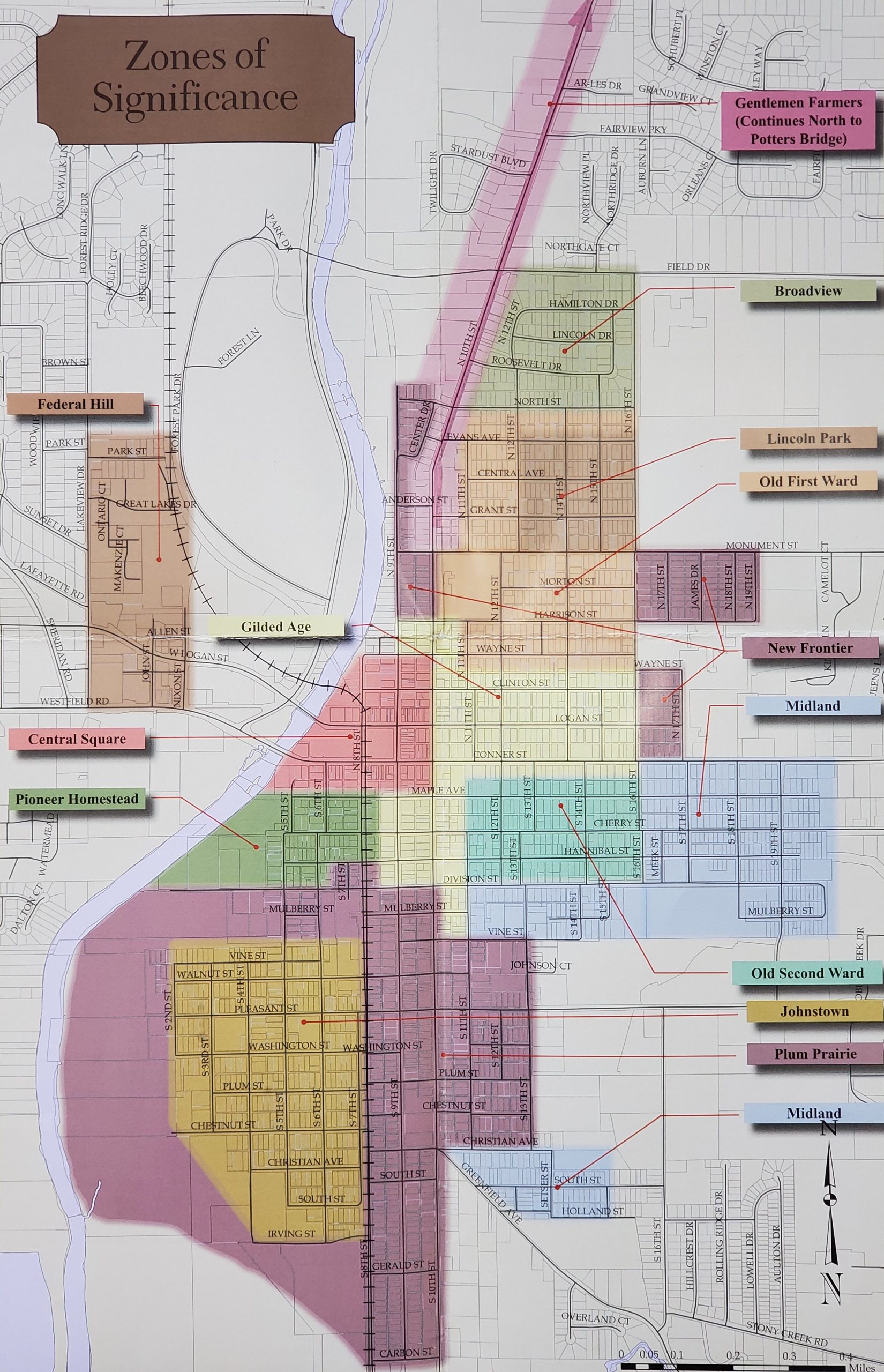
As population and social activity has increased through the years, the city has grown outward from its central core. Despite a drop during the first half of the 20th century, the city population in 2000 had grown to be almost equal to the population of the entire county in 1900. This growth, and socio-economic changes that it brought, have created a map of Noblesville that is as clear as anything drawn by a surveyor.

There have been discussions about historic preservation in Noblesville since the 1870s. However, most of the successful preservation projects have occurred since the creation of the Hamilton County Historical Society in the 1960s and the Noblesville Preservation Alliance in the 1980s. The city presently has eight buildings and four historic districts on the National Register of Historic Places.

The Zones of Significance were created as a way of establishing what resources were available for historic preservation. They are meant to be a tool for education and have no legal meaning with regard to historic districts. The Zones were established according to the general age and styles of the buildings within them. Most follow a natural pattern of community growth.

It is hoped that city residents will view the Zones as a starting point for creating historic districts of their own. If the homeowners want to keep the historic tone of their neighborhood, the Zones will help them identify what time period the buildings should generally reflect. In the end, the goal of this project is to encourage more involvement in historic preservation.